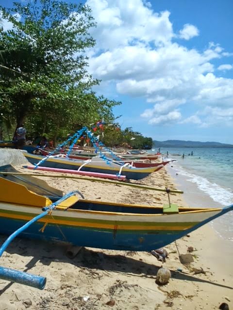
Trip to Mactang Historical Beach, Poro, Camotes Island, Cebu, Philippines
I went with my neighbors on a 4-day vacation at Mactang, Esperanza, Poro, Cebu to attend the local festival of the sitio's patron saint, St. Vincent Ferrer on April 23. Mactang is where my neighbors hailed from and I'm curious of how the place looks like so I went with them like on an immersion trip.
 |
| The Dike. See kid's doppelganger on the panoramic glitch. |
The dike's my favorite part. As I stood only 4'9” in height, I could dive in almost perfect form. Kids love to jump on this side too. Come on, just imagine that you don't have to go far out into the sea just to go deeper. More importantly, for as long as you're small, you can dive!
You can see about 3 mangrove trees slightly to the middle of the picture.
For this trip, I borrowed the cellphone of my neighbors' youngest son. Pardon me for capturing some pictures vertically, I have issues with the phone's touch screen setting and therefore, I had a hard time handling the phone's photo features in horizontal form. Fortunately, I was able to experiment with panoramic shots even though in failing manner.
When you say Camotes Islands, it's a group of 3 major islands namely: Ponson, Poro and Pajican and a minor islet called Tulang Diot (diot means small). Pilar is the town of Ponson Island while San Francisco is the town of Pacijan Island. Poro Island is divided into 2 towns, namely: Poro and Tudela. Tudela is small compared to the relatively staggering size of Poro.
There are various shipping companies you can choose from in going to any of the Camotes Islands from the port of Danao City, Cebu. The boat we rode docks at Consuelo of San Francisco. To reach Poro, there's a road streamlining San Francisco to Poro along a vast mangrove forest.
 |
| View from Consuelo Port in San Francisco |
 |
| Using phone's panorama feature from the boat |
The Camotes group of islands is under the Presidential Proclamation 2152 of 1981, declaring all the islands as Mangrove Forest Swamp Reserves and therefore withdrawing them from entry, sale, settlement or other forms of disposition, subject to valid private rights, if any there be. With this, no one from the islands can have land titles (cannot really own a parcel of land), instead the locals get "Tax Declaration". Because of this, investors are discouraged from opening up businesses, hindering the islands from developing their economy and established communities (way before the Spaniards came) from improving their already impoverished lives.
I think it's really unfair to have places in the Philippines under acts like this without due consideration. The locals live for hundreds of years in an island, foreigners came for conquest, eventually the islands became more developed as a nation and suddenly, the locals are just deemed never to really wholly own their homes. It's weird to be living in a land that you cannot really call your own. Aside from high prices of goods in the provinces, it's also partly the reason why the locals tend to flee the island and live poorly in cities in hopes not only to feed themselves better but also to buy lands of their own.
For Camotes Islanders, it was just so unfortunate for them that they truly love nature that they were able to preserve it. Other islands on the other hand had already managed to tamper with their natural resources that they were all allowed to develop more. I’m not saying that we should have depleted our mangrove trees, rather, that the current president should already pass the bill to balance the conservation of natural resources and development of Camotes.
As a descendant, it's disheartening to be inherited with a parcel of land that is not really mine. My family "owns" a parcel of land at Buenavista, Tudela on the other side of the island.
 |
| Left side of the dike |
I was playing on the phone's zoom when I accidentally captured this:
You can see the kids standing on the dike. That blurred jut of land beyond the sea is actually San Francisco.
 |
| This is my neighbors' son. Up ahead, you can clearly see San Francisco island and on the upper left, the dike. |
 |
| From where I stood, this was the left side view. |
 |
| While this one's the right side. |
 |
| with Hazel Ann "Antolin" mulling |
 |
| These two are my neighbors’ twin granddaughters. |
 |
| Antolin is the one in the middle. |
The water is really clear, only marred by dead leaves and tree trunks. Mactang Historical Beach is still the Republic of the Philippines' property and therefore, open to the public.
Kids notice I was taking pictures so they pose. And the picture failed miserably for I was still playing with using zoom. *le sigh*
I could have taken lots of pictures (like photo of my feet under the water) but I was only limited to 15% of battery left of the phone's measly battery life.
Swimming at the Mactang Historical Beach was a fun experience, most especially diving from the dike.


We love to hear from you
Post a Comment